Mapping for Economic Development (Kenya)
An open-source geospatial dataset that fuses population, age demographics, boundaries, poverty, crime, POIs, and infrastructure into H3 hexagons to power data-driven decisions.
Project Overview
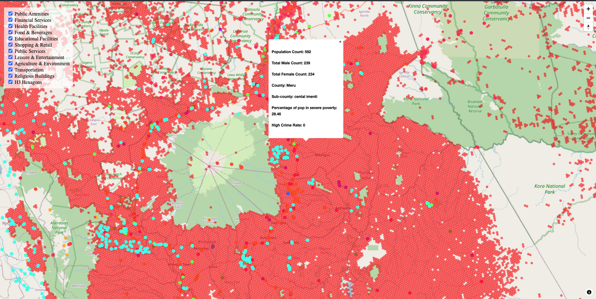
This project curates a novel, open-source dataset to support economic development across Africa, starting with Kenya. By unifying geospatial and demographic signals into a common H3 hexagonal index (≈400m resolution), the dataset enables businesses, researchers, and policymakers to analyze regions, build affluence scores, and prioritize interventions— all from a single, consistent source.
Motivation
Inspired by firsthand exposure to regional development disparities in North and East Africa, this work aims to reduce the friction of geospatial analysis. Consolidating open data into one place lowers barriers for evidence-based decisions— from business expansion to public resource allocation.
Data Sources (High-Level)
Population & Age
Kontur population (H3 at ~400m) and WorldPop age/sex rasters aggregated into hexagons.
Boundaries
County and sub-county administrative shapefiles to label each hexagon by region.
Rail & Waterways
HOT/OSM railways and waterways lines to capture access and infrastructure context.
Financial Services & POIs
HOT/OSM points for banks/ATMs and broader amenities (health, education, retail, public services, etc.).
Poverty & Crime
MPI (OPHI/HDX) sub-national poverty indices and a derived sub-county crime hotspot indicator.
Notes: Many sources are open and regularly refreshed (e.g., HOT/OSM). Where applicable, data is used under permissive licenses (e.g., CC BY 4.0). See the repository for provenance and citations.
Methodology
- Indexing: Convert rasters and vectors to
H3resolution 8 (~0.74 km²). - Aggregation: Summarize age/sex rasters per hexagon; merge with population counts.
- Enrichment: Join administrative boundaries; attach MPI (poverty) and crime indicators.
- POI Segmentation: Group OSM points into thematic slices (health, education, retail, public services, etc.).
- Exports: Publish consolidated CSVs keyed by H3 ID for easy analysis and mapping.
Potential Applications
- Business & Market Sizing: Build affluence scores, locate underserved regions, derisk expansion.
- Urban Planning & Infra: Prioritize transport/utilities where poverty is high or access is low.
- Food Security & Climate: (Future) Integrate environmental/land-use layers to study resilience.
- Public Safety: Target crime hotspots and evaluate policy impact geographically.
- SDG Tracking & Services: Monitor progress; guide allocation of schools, clinics, and social services.
Technology Stack
Core
- Python · Pandas · NumPy
Geo
- GeoPandas · Rasterio · Shapely · GDAL/OGR · H3-py
I/O & Viz
- GeoPackage/ESRI Shapefile · CSV · (Future) Plotly dashboards
Key Features
- Unified, hexagon-indexed dataset at ~400m resolution.
- County & sub-county tagging for administrative rollups.
- POI segmentation (health, education, retail, public services, etc.).
- Poverty and crime overlays to contextualize opportunity and risk.
- Open scripts for reproducibility and extension to other countries.
Preview
Roadmap
- Extend coverage beyond Kenya to additional African countries.
- Add environmental & land-use layers for food security research.
- Publish interactive dashboards for exploration by non-technical users.